Nature is all around us - in partnership with leondeleeuw.net
Written and photos by Leon De Leeuw, edited by Gabriella Permaul.
Sofia lies in a large valley, at an average altitude of 550 metres. There are no large rivers in the capital, however, it is surrounded by mountains. Vitosha mountain, with the Black Peak (Cherni Vrah) at 2.290 metres, is the highest mountain nearby. The mountain Vitosha has nine other peaks that reach over 2.000 metres. In prehistoric times, it was an active volcano.
North of Sofia stretches the Balkan mountain range (Stara Planina). It stretches all the way east into the country and west into Serbia as well. Without going into too much detail; it's clear that nature in Bulgaria is everywhere. We should be thankful it’s right on our doorstep. This is true wealth. Nature can heal us and we need it more often than we think. It's where we come from and city life, although enjoyable, only does us good up to a certain point.
I find myself drained frequently and often feel the need to recharge. This is best done in nature and, for me, alone. It's strange how little time we spend in the sand or walking on grass. We tread on concrete and pavements and only through parks. There's a moment of connectivity when you walk through the forest and feel your feet sink in the sand or kick up autumn leaves. If you're present in the moment, nature can offer so much. Just by observing objects closely, a pretty flower or a dense forest can trigger all your senses. Fresh flowers in spring, pine forests enriched with rain; these are the smells that bring us back to childhood and remind us of those carefree days.
Nowadays we connect too little to nature. Nature starts in our backyard or in the garden right in front of the apartment block. But how often do we really look at a pinecone? When was the last time we looked at bees circling around a flower? We do it rarely, even though we can right now. These things can be found in the city yet we choose to ignore them in our busy lives. We look at screens and scroll through social media feeds, looking at pictures of people who travel and post pictures of nature, the same nature we choose to ignore even though it's all around us.
There's no need to travel far to find nature. In this post, I will show several itineraries that I truly enjoyed. They are near Sofia and easy to reach. Still, as most paths are not marked, it's good to have some means of navigation. Google Maps, maps.me, a compass (possibly your phone but batteries run flat) and a map are a must. If you prefer a marked trail, Vitosha mountain offers many of these.
Bistritsa - Pancharevo
Take bus 98 south to Bistritsa village. Get off there and visit pastry shop Foreste. You can then hike along the path towards Pancharevo Lake (Pateka Pancharevo - Bistritsa). To find that path, get the free application Citymaps2Go and download the Sofia Province map. Then, you can swim year-round in the outdoor hot mineral water bath Korali (09:00 - 19:00) and take bus 1,3 or 4 back north into the city.
This is the first itinerary, also mentioned in the article Enjoying Sofia in winter.
If it happens to be a weekday, have a coffee at Arhivite. This is the National Archive and an interesting place to see.
Novi Iskar - Katinskite Piramidi
In the Iskar gorge, stretched north of Sofia, there are many villages ready to be discovered The landscape turns hilly right north of Sofia, where he village Novi Iskar is situated. Its train station is called Kurilo. You can get there from Sofia in about 25 minutes by train. From there on, you can walk northwest and head right into the forest. There are several paths you can take, it's best to just explore it yourself.
Downloading an offline area of Google Maps will definitely help you find some (unmarked) paths. The pine forests will continue on to the settlement Laska and then to the Katinskite Piramidi, the stone pyramids near the village Katina. These places are all easily found on Google Maps. You can then walk on to the village Katina and take bus 27 to metro station Lavov Most (Lion's Bridge). A nice route that you do not need much time for, I did it myself in about three hours. It's perfect for a quiet afternoon. You'll have some places from which you can see Sofia so there's plenty of opportunities to take pictures. East of Novi Iskar are some paths as well, however it's better to continue by train to the next stop, Vlado Trichkov village. That area has more forests.
Thompsan - Vlado Trichkov
If you find yourself in Thompsan or Vlado Trichkov, you can directly walk from one village to another because both are conveniently located along the railway line. As there is no pavement, the road connecting them is not too suitable for hiking, It's safer and far prettier to take the hills. I started in Thompsan and walked to Vlado Trichkov, however, either direction is possible. This is not a marked trail, I walked it just by using a map. I recorded my walk with Viewranger, an excellent app. I downloaded an offline map of the area and then walked using a paper map because it showed each path in that area.
The route is posted here for your reference, you may download it and follow the trail yourself. I really found this to be one of my best hikes. It's a diverse and hilly terrain. You should be very careful as this is not a path that's frequented by hikers. There are several signs warning you for hunters so do not head off the paths. Make yourself visible and be extremely careful if you have a dog that doesn’t go off into the bushes. Should you want complete certainty, don't take this route. The area is popular for hunters and they can be on any unmarked trail. There are plenty of marked ones near Lakatnik and Gara Bov.
Thompsan - Tseretsel - Chibaovtsi - Svidnya
A hike of at least 25 kilometres. From Svidnya, you can take a bus back to Svoge or to Iskrets to spend the night there. It's best to take the route this way because it fits perfectly. Take the 11:20 train from Sofia to Thompsan, do the hike, take the 18:45 bus from Svidnya to Svoge, have dinner at Soleil and take the fast train back to Sofia at 20:35. Fast trains do not stop at Thompsan so your last train to Sofia from there would be around 18:00.
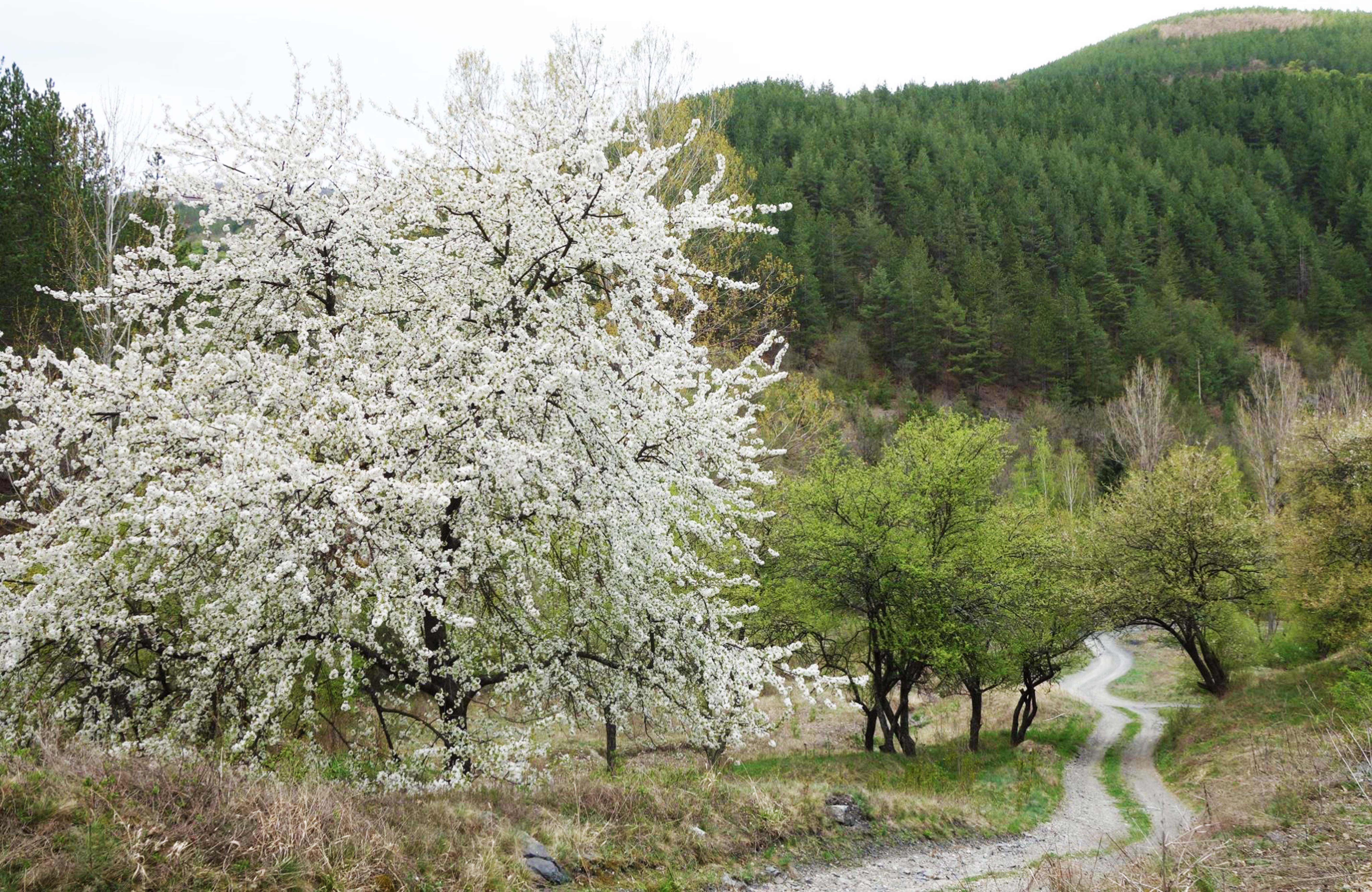
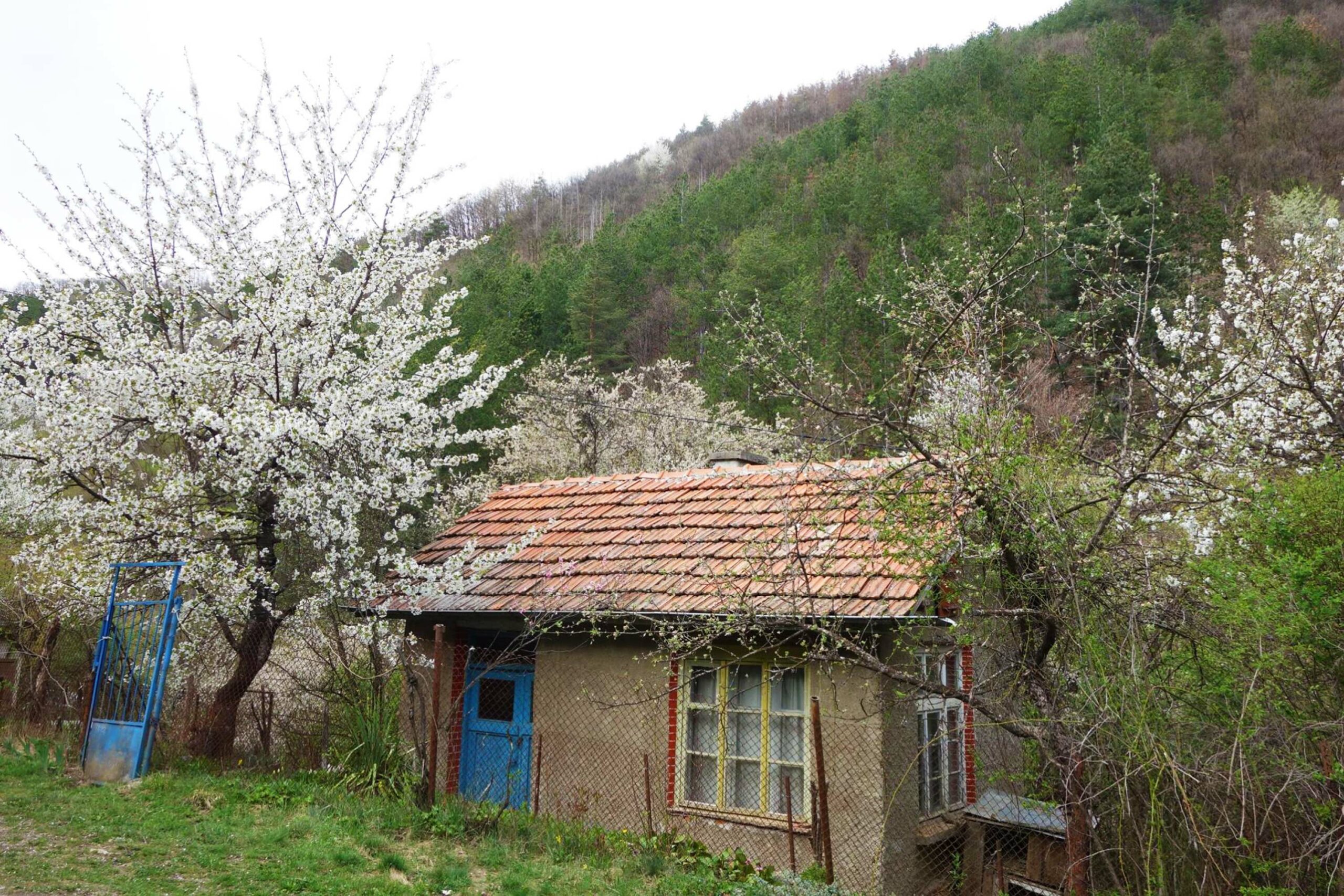
On the other hand, if you end at Svoge, you have more time and can take a late train back. Fast trains do stop here. I found this to be the most beautiful hike of all the ones listed. Besides, it's easily accessible; it's just the distance that you'd need to be trained for. The greenery is stunning; green mountains all around and it's a varied trail as well. You pass through settlements, pass vacation homes and abandoned houses. There are some occupied homes along this route so be careful of the dogs that roam free. Rarely anyone passes by those roads so the owners are used to letting their dogs off the leash.
Lukovo - Novi Iskar
On a Sunday morning, I decided to take a train to Lukovo. I hadn't gotten off the train there before so I was curious as to what it would look like. It's a small village with a shop and houses against the mountain. The railway line separates the village in two halves. I just had my phone and a map, with hiking trails with me. They do their job just fine.
I found a small store, bought some water and decided to record my trip from that point on. I had some trouble finding the path east. I decided I wanted to see the mountain Turska Mogila (843m.). I asked two ladies, who had just returned from a hike, for directions. Still I took a wrong path, but I ended up at a nice viewpoint from where I could see the village Vlado Trichkov. The path eventually led to dense bushes and I returned. I came back to the initial path and took the other turn, which led me to the mountain Turska Mogila. Should you follow my route on ViewRanger, you can disregard that part and continue where I turned right initially.
Also, please note that I paused the application at some points to have a break. I then forgot to switch it back on and when I did, the itinerary was drawn as a straight line. Follow the path and direction of the app. This explains the straight lines on the map. Admittedly, the Turska Mogila mountain was quite steep and hard to climb with my Nike shoes.
The path literally passes the summit of Turska Mogila mountain. There's no view from the top of the mountain, as it's a dense forest. Yet from that point on lie beautiful views. On your left, far down into the valley, is the village Thompsan and its train station. Then, you come past a small, abandoned settlement. There's a lot of decaying asbestos roof sheeting so best not to get too close. Do not touch it under any circumstance. Then, as you follow the map, you come past some places to have a rest. There are some benches and wooden tables. You continue through the forest and the only people you may see are just some guys driving through on their motorbikes. You'll pass several houses, most of which are abandoned. I did pass one family home, judging from their garden, completely self-sufficient. They even generated wind power.
There are wide views over Sofia. The landscape also really changes, from bushes to tall pine trees. Some parts are valleys where it's humid and other parts are on sunny hillsides, which are a lot greener. You truly feel far from anything on this path; you'll find absolutely nothing but nature. Eventually, you have the choice to turn to Vlado Trichkov. There's a train station there. You'd then end up on the south side of that village and would have to walk on the main road for a while to get to the station. I assume there's no pavement so continue to walk through Novi Iskar village instead. The landscape turns from mountainous to hilly. It's gentle and pretty. When I was there, I eventually descended into Novi Iskar and saw some nice views of the village and Sofia from afar.
As you keep walking, you'll get to the main street of Novi Iskar. There are buses that go to Sofia's Han Kubrat and Obelya metro stations. Alternatively, continue to Novi Iskar train station and get back to Sofia that way. The station of Novi Iskar is called Kurilo.
Gara Bov - Ivan Vazov's Eco Trail
Provided that the weather is suitable and you have good walking shoes, the Eco Trail in Gara Bov is definitely a good choice. Trains from Sofia/Svoge to Gara Bov leave regularly. Get a ticket, hop on and get off at Bov station. From Svoge, you arrive in Gara Bov in approximately 13 minutes.
Leave the station towards the bridge crossing the Iskar river, the main road is right in front of you. Make a right turn, walk until you see a sign with 'Touristic Road Vazov's Path' pointing left. After fifteen minutes uphill, the road turns into a gravel path. After thirty minutes of hiking, the waterfall is in full sight. From this point, it takes another fifteen minutes to stand right where the water hits the rocks. Standing in front of the clattering waterfall on a hot summer day is fantastic. If you'd like to see more of the area: the trail continues upwards to the village Zasele, located right above the waterfall. The climb is steep but offers nice views of the Iskar gorge once you make it up. From there, you can retrace your steps or make a two-hour detour via another gravel road, starting on the other side of Zasele. This route is shown on Google Maps.
Gara Bov - Pod Kamiko Waterfall Trail
The second trail goes northeast of the village Bov. By following it you get to see a waterfall as well. This trail, the Green Route, starts from behind the 'stadium' of Gara Bov, which is just a large soccer field. You reach this field by walking straight ahead from the train station. If you exit the train coming from Sofia, it's on your right. You don't cross the Iskar river on your left. Right before you go uphill, there is a map of Gara Bov and the route you are about to take.
In about three hours, the path takes you to the waterfall, through dense woods, along steep hills and past abandoned houses. In the end, you have the chance to visit the 'Vazova Kushta', where Bulgaria's famous poet and writer Ivan Vazov spent his days writing. The trail ends at the same place where you started. It is an easy hike through lovely scenery and therefore it is absolutely perfect for a day trip from Sofia.
Zhelen village
Eight kilometers from Svoge is the community Zhelen. In case you'd like to go on foot; the road ascends gradually, making the walk easy. To find the road to Zhelen; head right from Svoge's train station, passing a small park alongside the railway. The descending road then makes a curve right up until the junction with 'Iskar Boulevard' - turn left and cross the short bridge. The green building on your right is Hotel Collosos, offering rooms from 15 Euros a night excluding breakfast.
To continue to Zhelen, pass under the railway bridge and keep walking. The village border starts three kilometers before the actual village center. There is a small store but you can never be sure whether it's open. The scenery and panoramas make this hike absolutely worth it. With some luck, an infrequent bus heads back down to Svoge - it's best to ask what time it leaves, provided it does.
(By turning right from Svoge's train station, your back should be towards the front of the station, in front of you is the large, foursquare shaped town hall.)
Iskrets village
About a hundred metres right of Svoge's train station is a small square where buses leave to villages nearby. You can venture out and take any bus - natural beauty guaranteed. Iskrets is a village that is frequented by one bus every hour, covering the nine-kilometer distance. On the way, you pass a chocolate factory, producing the well-known Svoge chocolate.
In Iskrets, you can simply hike through the village and stumble upon some classic, seemingly abandoned cars. Alternatively, take the long but scenic, winding road up to Breze village. I walked around Breze village through the hills, there are several paths leading up. Some in the open, some through the forest. The surroundings are great. I walked all the way back from Breze to Iskrets. The road is paved and quiet, excellent to walk on. Buses back to Svoge leave from the same place where you got off. Good to know - departure times from both Svoge and Iskrets are listed at Svoge's bus station.
Iskrets - Dobarchin - Mecha Polyana - Tserovo
In Iskrets lies the Tsar Ferdinand sanatorium, for lung patients. If you walk through the gates, past the small monastery you will get to Dobarchin village. Then, go to Mecha Polyana, which is one of the most beautifully located settlements in Bulgaria. Walk there from Iskrets or Tserovo, read more and see pictures here!
Read more about Svoge, an ideal basis for all your hikes. Lakatnik and Tserovo, perfect places for similar hikes, deserve their own articles. Let me know should there be any questions!
In my 'Bulgaria section,' you can find many more places to travel to!
Gara Lakatnik - Selo Lakatnik
This route is excellent for a day trip as well. It's part of the Kom-Emine route. The longest and oldest trail of Bulgaria, which passes about a hundred mountains. Many Sofians know Lakatnik, it's a place popular for hiking, mostly because of the tall cliffs. However, there's more than just these cliffs.
Lakatnik has a separate article, which is about these cliffs. Here, I share with you a hike that's a bit more 'off the beaten path'. If you travel through the Iskar gorge a few times, you'll notice that there are villages that have similar names. Such as in this case, there's the actual, old village Lakatnik. It's high up in the mountains.
When the railroad through the gorge was made, these villages were still far from the railroad. Obviously, the railroad lies next to the river and does not go high up into the mountains. The village's station was down in the valley. Then, when the railway line was used more often, the stations became places of commerce and trade. Eventually, shops and houses were built around these stations, on the hillsides.
Because the station was called Lakatnik, it would be strange to have a village around the station having another name. Therefore, the village was called 'Gara Lakatnik' (Station Lakatnik). The village up in the mountains, the original Lakatnik, then turned into 'Selo Lakatnik' (Village Lakatnik). The same is the case with 'Gara Bov' and 'Selo Bov'.
This hike is from Gara Lakatnik to Selo Lakatnik, and back The advantage is that you can choose which way to go. There's the paved road in between the villages. There are not too many cars on it, but you should be careful around the curves. It’s a pleasant hike uphill. There are several small paths branching off from the road, leading to beautiful fields with flowers and, often, views on the Lakatnik cliffs.
Stunning views all around. If you get to the Selo Lakatnik, there are about two small stores where you can buy refreshments. Don't expect much, and there's a chance they could be closed. Apart from that, there's a small post office, the most beautifully situated I have seen and a church and a library. Not much more, just a quiet village. Yet, the backdrop of the mountains is so pretty. You can look around a bit and then walk back to Gara Lakatnik. There are buses going to Gara Lakatnik however there is no schedule at the stop. On a sunny day, what's better than walking back? You can take another path that goes through the forest, so I recorded it for your reference. A nice, shady path, excellent for a hot day. Not so enjoyable after the rain and the sun don't dry the path because it's so shielded by trees. I really enjoyed this hike. If you don't want to return and prefer to end the day at another place, continue towards Selo Bov. You can sleep in mountain hut Trastenaya. Find it on Google Maps by typing 'Trastenaya'. If you want to go back after having slept there, it takes up to 12 kilometres to reach Gara Bov where there's a train station on the line Sofia - Mezdra.
Gara Lakatnik - Goubislav
The trail mentioned above is part of the Kom-Emine trail. It goes east from Lakatnik. If you want to go west of Lakatnik instead, you can follow the Kom-Emine trail in that direction as well. As this page is quite full with hikes around Lakatnik, there's the Lakatnik page itself and then the Lakatnik - Goubislav page which describes the Kom-Emine trail west of Lakatnik.
Eliseyna - Zverino
71 kilometres from Sofia, past Lakatnik, is Eliseyna. About5 kilometres east is the village Zverino. Both have train stations so you can walk in either direction. There are slower 'personal' trains to Eliseyna. Intercity trains stop at Zverino too. Directly behind the station of Eliseyna is a road right uphill. Then, you cross the main road and go left at the first side road.
You can follow the route on Google Maps. Alternatively, I recorded the trip with Viewranger. It's an easy hike, however, the grass is quite tall in some parts. Better to have your legs covered because of ticks. I also saw two snakes. The views are very pretty, with the landscape starting out green and hilly. Near Zverino, the landscape turns rocky and dry. I haven't seen a store around the station of Eliseyna but at Zverino there are a few.